
Sooner or later, you will find yourself on Rte. 212 southwest of Saugerties. We use that stretch of the highway when we go to Opus 40 or on to Woodstock. Our most recent drive was back in autumn. It was in upstate New York; were we watching out for some beautiful fall foliage? Don’t be silly; of course not! We are always on the watch for some interesting geology, especially if we can turn it into a column. We’re good at that because we have been in the business for decades. We truly have trained eyes – and minds.
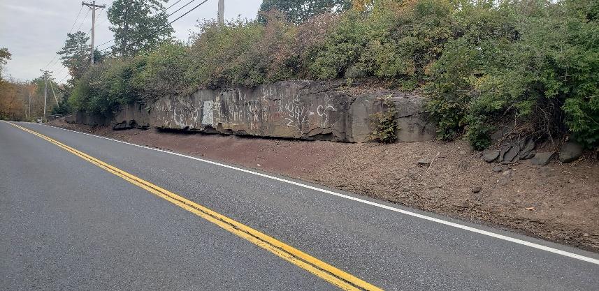
Take a look at our photo. We took it when we were going down Rte. 212 to do a PowerPoint lecture. There it was, right along the right (northwest) side of the highway. We saw a fine ledge of rock. That’s not terribly unusual, is it? We see similar outcrops all over, in fact everywhere we go. But this one was special. Look carefully and you will just make out a smooth, flat and vertical surface, a wall of rock. And there was more; as we drove down the road, we passed several other outcrops, and each one displayed the same things. Smooth walls of rock seemed to be in fashion in this part of the town of Woodstock. That, indeed, was unusual. Once again, like so many other times, we had some explaining to do.
We have written about these features several times. This sort of wall is a structure called a geological joint. Geologists like to say that the rock here is jointed. There was a chapter, - no, a moment in time - when all this rock came to break up along those fractures. The likely explanation has to do with plate tectonics. We think that it went something like this: several hundred million years ago Africa collided with eastern North America. The collision squeezed the bedrock all along the collision zone. That actually did very little harm to those rocks, but then Africa broke away and began drifting back to the southeast. That’s when the pressure on those rocks was so reduced that they became unstable. They expanded and then they fractured along many, many of those joint planes. Given time, and we mean a lot of time, weathering and erosion brought those joints to the surface, many of them along Rte. 212. Had we solved our problem? Nope - not quite – not yet.
But that did get us to the next problem that needed solving. Why were there so many of these joints exposed along this stretch of highway? That is unusual; it does need explaining. We got a good map out and, bingo, there was the solution! It just happens that Rte. 212 has a northeast-southwest compass direction hereabouts. That’s important because those joints all display the very same pattern. Africa had approached from the southeast in its collision, and it had drifted back the same way as it departed. All the bedrock here had been squeezed and then expanded along the same compass orientation. When they built the highway, long ago, they had to cut onto the bedrock and of course that exposed the joints. All of them are parallel to the road. Now, we had, indeed, solved the whole problem.
All these mental gymnastics were not the least bit unusual for the two of us. We had gone out for a drive and found puzzles exposed in the roadside rock exposures. We pondered these and, when we got home, got that map out and cracked the problem. Geologists are like that. In fact, all scientists are like that. Keep reading our columns, maybe you will become like that too. It could happen.
Contact the authors at randjtitus@prodigy.net. Join their facebook page “The Catskill Geologist. Read their blogs at “thecatskillgeologist.com.”


0 comments:
Post a Comment