
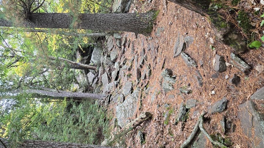
Do you do a lot of hiking here in the Catskills? If so, then you may have noticed that, from time to time, your trail, especially if it is going uphill, will cross a very large ledge of gray to tan sandstone. You have to climb over it and that can often involve some tough scrambling. Is this just one of life’s random nuisances? Or is there something more to it? It’s not likely that you have ever wondered why this sort of ledge is there. There is really no reason why you should have. But that’s just the sort of question that geologists ask all the time. Recently we went to North Lake and headed north on the Blue Trail. Soon, after less than a ten-minute walk up the trail, we encountered one of these ledges. Take a look at our first photo. That ledge tops out after about a 30-foot rise in the elevation. You scramble up the lower part of the slope. Then you veer to the right, then climb up a four-foot-high sandstone. Then you veer to the left and hoist yourself up another thick sandstone. You walk a few more steps to the left again and climb up one more stratum. That brings you almost to the top; after that the Blue Trail has a long flat, northbound straightaway, but it isn’t long before you encounter another one of these ledges. Later you will see another ledge and, later still, one more. There is a pattern here.
Maybe you remember what we always say about patterns. They are Nature’s way of telling scientists that there is a problem that needs solving. What’s going on here? We were wondering just that when we noticed there was a way to climb off to the right side of this ledge and get a better look at these strata. That took us off to a very fine cliff exposure of these very same beds. See our second illustration.
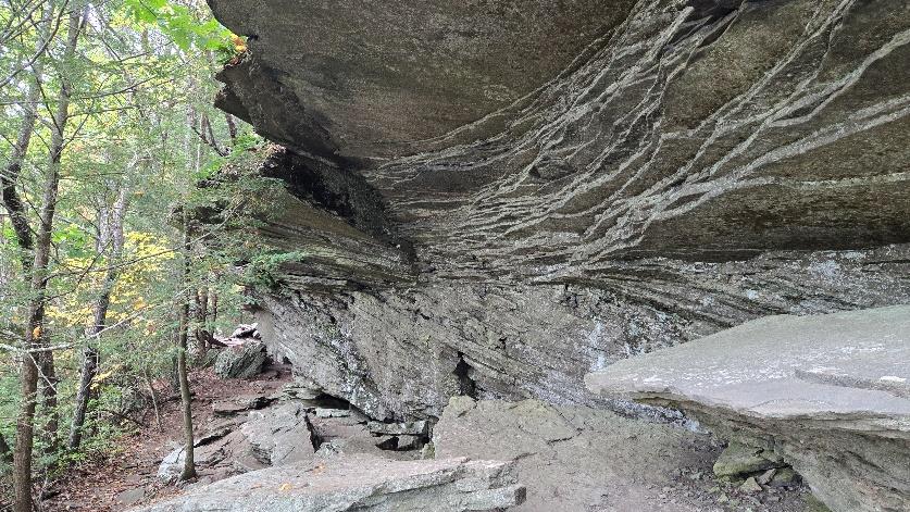
There must be at least 15 feet of continuous strata exposed on that cliff face. That’s a nice slice of bedrock and this one had a lot to tell us. Take a look and see what you can see. There is an overhanging ledge of rock at the top. The strata up there are flat lying.
Below that are three or four feet more strata. These are very gently inclined to the left. Then at the bottom are a couple more feet of, this time, right leaning strata. It sounds like the rocks are trying to say something, doesn’t it – written in rock language. We speak and read Catskills rock language pretty well and we soon saw what those rocks were telling us. This is a cross section of an old stream channel. The lower sands were once deposited in that channel at the very end of a flood. Later there was another flood and then, later on, still another. Flood waters first flowed this way and deposited sand. And then later they flowed that way and deposited more sand. Back and forth it went, flood after flood. Then the stream was re-routed and flowed off in a different direction – never to return. At least it did not return for thousands of years. When we climb uphill on the trail far enough, we will encounter another ledge, and we will see the sands of that same river when it finally returned, or perhaps another river, when it first arrived here. Later there is another ledge. That’s another stream. And so it goes; there really is a pattern here. You may have seen it many times, without even knowing it.
Contact the authors at randjtitus@prodigy.net. Join their facebook page “The Catskill Geologist.” Read their blogs at “thecatskillgeologist.com.”
Remember to Subscribe!


0 comments:
Post a Comment